LeakBySat, satellite water leak detection

Temporal
LeakBySat
× STEPS
Reference | Water, satellite and AI

LeakBySat, detecting leaks from space

LeakBySat is data analysis software that studies water networks, detects leaks from satellite imagery and predicts fraud using artificial intelligence. Risk areas are mapped to guide field teams.

Satellite imagery
AI detection
GIS mapping
01 - The context

What you see, and what gets lost

Much of the water lost escapes underground, out of sight. Networks are extensive and teams cannot inspect everything.

ABOVE GROUND
Extensive networks

Kilometres of pipes to monitor, across urban and rural areas.

Costly inspections

Sending teams out at random takes time and resources.

UNDERGROUND
Invisible leaks

Many leaks never reach the surface and stay active for a long time.

Fraud that is hard to spot

Unauthorised consumption blends in with network losses.

02 - How it works

From orbit to the field

SPACECOMPUTEGISSOL
ORBITSatellite imagery

Satellite images cover the network over large areas.

ANALYSISAI detection

Models spot abnormal moisture signatures along the pipes.

MAPRisk areas

Suspicious areas are matched with the network layout and mapped.

FIELDTargeted inspection

Teams go straight to the flagged areas.

03 - The interface

Leaks, visible on the map

Network files (shapefiles) and satellite images are overlaid to show leak areas.
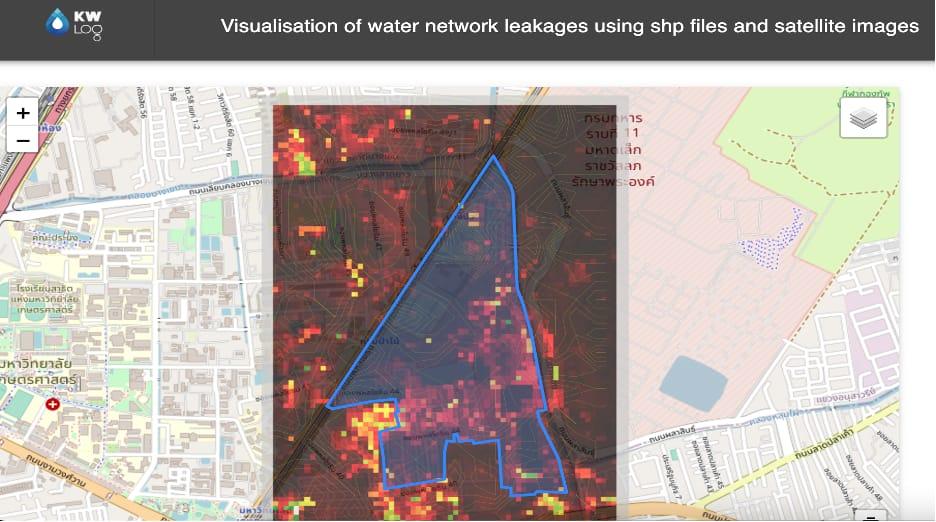
Leak visualisation on satellite imagery
1Analysis area
2Leak signal
3Base map

04 - The functions

Four functions, one map

Image analysis

Satellite images are processed to measure ground anomalies.

Leak detection

AI flags the areas where a leak is likely.

Fraud prediction

Suspicious consumption is spotted on the network.

Mapping

Areas to inspect are published on a map for the teams.

05 - The benefits

What LeakBySat changes for water managers

Search less, find more

Instead of covering the whole network, teams receive a map of priority areas and focus their resources where water is being lost.

Targeted inspections

Teams go where a leak is likely.

Fewer losses

Leaks are found and repaired sooner.

Wide coverage

Satellites cover hard-to-reach areas.

Less fraud

Unauthorised consumption is detected.

Documented decisions

Every intervention is based on a map.

A preserved resource

Every leak repaired is water saved.

06 - Our work

From satellite image to inspection

PHASE 01Data

Collection of satellite images and network files.

PHASE 02Models

Training of leak and fraud detection models.

PHASE 03Software

Visualisation, layer overlay and area mapping.

PHASE 04Field

Reporting to teams and inspection follow-up.

07 - Architecture

Under the hood, stacked layers

Satellite, AI and GIS: each layer adds information, and overlaying them reveals the leaks.

FAQ

Frequently asked questions

Do sensors need to be installed on the network?

No. The analysis relies on satellite images and network files.

Do the results replace field teams?

No. They guide them to priority areas, where inspection confirms the leak.

Can the solution detect fraud?

Yes. AI models spot suspicious consumption on the network.

Is your network losing water and you don't know where? Let's talk about your project.

Book a scoping session ↗